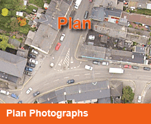
Plan Aerial Photographs
High resolution up to date plan aerial photography.
 Whether you are simply considering, developing or monitoring land we can provide your organization with custom flown ortho-like GIS ready plan aerial photography within a matter of days.
Now you can have up to date detailed visual information of property, where access on the ground may be limited.
Potential development land can be viewed and considered without the competition or local residents knowledge.
Ideal for projects such as master planning of towns and cities, production of 3d models of major developments by architects and developers, forestry, and land usage surveys.
Aerial Photographs are an especially useful tool for communicating with local residents & businesses at public meetings, enabling all concerned to easily identify their respective properties.
Benefits:
- Can help reduce overall cost
- Enhancing communication
- Aid in better decision-making
- Save on repeated field trips to the site
